Saturday, June 21, 2025

Lacombe Lake

In late April, I stopped at Lacombe Lake on the way back from Calgary. I use the public boat launch off Township Road 402 in the NE corner of the lake.


The launch was lovely (and empty) with a shallow gravel entry and pretty clean water. There are no bathroom facilities here (I would guess the closest would be in Lacombe or Blackfalds. It was a windy day (from the south) so I padded down the east side of the lake and into the small beaver pond.


Lots of birds here, including loons. No beavers on this trip but I did see a muskrat.


The TransCanada Trail runs down the east side of the lake.


I went back out into the main lake and worked my way to the south end of the lake.


The picture below gives you a pretty good sense of the overall experience. The shore is reeds that give way to aspen and fir forest. There are hills on the east side and a farm on the west side.


The wind really came up for the trip back. I usually paddle about 4 km an hour (very average). The trip back down the lake saw me do as much as 12.6 kph (it was really blowing--fortunately the lake is shallow, so the waves were not too bad).


The lake is probably about 8 or 9km around so it's a two-hour paddle if you do the whole thing. If you wanted a shorter paddle, down the east side and into the small bay is interesting. The southern end is also okay. The north end of the lake is the least interesting and is the part to skip.

Saturday, June 14, 2025

Anglin Lake, Prince Albert National Park, SK

In late June, we spent a morning on Anglin Lake, just south of Prince Albert National Park. Anglin Lake is a reservoir and sprawls over a large area. One option for entry is the Great Blue Heron Regional Park on the eastern end. There is a day-use fee here ($10, I think), a campground, standard boat launch, and a beach with put toilets and a picnic shelter.


This entry offers good access to the eastern part of the lake. The water looked lovely and was mostly empty when we were there (one kayaker and one guy unloading a fishing boat).


A second option is the Anglin Lake Bridge, about two-thirds of the way towards the west end of the lake. Again, a day-use fee applies. This allows access to the western basin (down towards the dam or up towards the Spruce River inflow) or the middle basin.


We decided to put in here because it looked the most interesting. Access is down a grassy slope on either side of the bridge. 


The west side looked easier but both required wet feet.


We paddled east, under the bridge and into the middle basin and did a circuit.


The middle basin basically looks like the image below: reeds and grassy slopes give way into an aspen forest. We saw a deer frolicking in the shallows (no picture).


We also annoyed this poor heron who flew off.


The lake was calm and mostly empty. On the south shore of the middle basin, there looks to be a public boat launch and we saw a fishing boat unloading there.


We paddled around a couple of islands before heading back towards the bridge.


A few dragon flies were rescued.


The western basin had more fir trees on the northern shore and was, overall, bit more rugged looking.


You cross into the National Park in this basin.


The inflow of the Spruce River  is just to the left of the trees in the picture below, but we didn't get that far up the lake.


After pulling out, we followed the road to the south end of the lake where the dam is. It was good walk from the parking area along the top of the dam and there were lots of butterflies.


The outflow of the dam itself was surprisingly small.


There is a launch here but this end of the lake looked a bit boring.


Overall, a pretty nice lake with enough to explore over several paddles. The folks we talked to said the fishing was also good (jack and walleye).

Elizabeth Lake

In late April, I stopped in Lacombe to try and get on Elizabeth Lake. I'd previously paddled nearby Barnett Lake and Elizabeth was similar. Access is DIY and I've flagged four options below, none of which are very good. 


A challenge everywhere is that (1) the lake is shallow and you have to pole or bum-scoot through the shallows to get out where you actually float compounded by (2) the lake level has risen and killed trees at the edge, meaning you also need to navigate submerged stumps while bum-scooting. This is not for the faint hearted and likely isn't a good option for inflatables because of the sharp sticks. 

I accessed the lake from the bottom (blue arrow) off the Elizabeth Lake Trail. You can park on Woodland Drive by the Canada Post box (30 meters west of the trail head), carry across the road at he cross walk and then hang a left down the paved trail, which quickly becomes dirt.


The closest access is at the very bottom corner of the lake (above). This was very shallow and stumpy. I followed the trailed another 30 meters (up a rise and then down to the lake again), carefully walked over the hidden logs in the grass, and got in here.


This still sucked and I had to pole out a fair way. Getting back out here also required some acrobatics. 
 

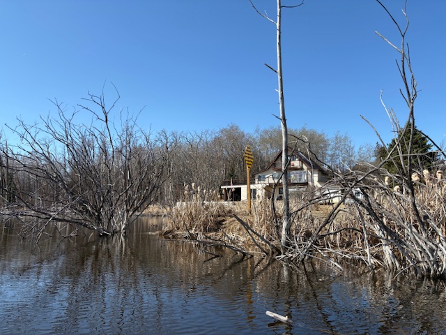
Below is basically what you get: shallow, murky lake with grass, trees and a band of dead trees right at or in the water. It is prettier in the summer with leaves. 


There were a fair number of birds and some muskrat and beaver. The lake is about 4km around and took about an hour.


You might also be able to get in on the east side (pink arrow) down a path. Again not great entry (did not get a photo) but a nice lady I talked to suggested there may be a dock here in the summer. No idea if that was true every year.


At the north end (green arrow), you could probably get in pretty easily between these trees (above). The issue is the long carry across playing field and the stupidly steep hill (you can see the school atop in behind the trees).


Finally, there is a road that abuts the lake (red arrow). You can see the sign for the end of the road in picture below and there are a couple of places you could set a boat into the lake and step down into it. The parking situation here is unclear (gravel road--are the ditches public property? who knows) and the neighbourhood gives off a bit of an uptight vibe.


All told, this was a meh lake and a hassle to get into. 


You can get the same vibe at Barnett Lake about half a km west with an easier entry. Or you can drive maybe 12km south and have a nicer paddle at Lacombe Lake. I probably won't go back here.


Saturday, June 7, 2025

Muir Lake

As usual, Muir Lake was the first local lake open, this year in mid-April. Likely that reflects the winter aeration and the consequently thinner ice.


The boat launch gate was still locked (doesn't open until May 1) but the dock was in and 95% of the ice was off of the lake. A quick lift over the rocks and short (200-foot) carry and the kid and I were on our way.


There was a tiny bit of ice around the island, blocking the west-channel. We tried to bust through but it was too thick, so we went around the east side into the southern half.


The county had not yet been out to retrieve the snow fences they put out each year.


The sun came out while we were on the water and it was super nice despite being only 10 degree.


The only animals of note were a pair of camera-shy loons and a bunch of angsty geese.


Overall, a good start to the year and a good shakedown cruise for her. This was her first paddle since she broke her wrist paddle boarding last summer.


It looks like North lake and Little Mere as well as Chickakoo were also open.