Showing posts with label Red Deer. Show all posts

Saturday, June 21, 2025

Lacombe Lake

In late April, I stopped at Lacombe Lake on the way back from Calgary. I use the public boat launch off Township Road 402 in the NE corner of the lake.


The launch was lovely (and empty) with a shallow gravel entry and pretty clean water. There are no bathroom facilities here (I would guess the closest would be in Lacombe or Blackfalds. It was a windy day (from the south) so I padded down the east side of the lake and into the small beaver pond.


Lots of birds here, including loons. No beavers on this trip but I did see a muskrat.


The TransCanada Trail runs down the east side of the lake.


I went back out into the main lake and worked my way to the south end of the lake.


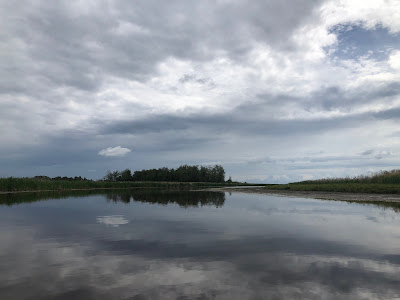
The picture below gives you a pretty good sense of the overall experience. The shore is reeds that give way to aspen and fir forest. There are hills on the east side and a farm on the west side.


The wind really came up for the trip back. I usually paddle about 4 km an hour (very average). The trip back down the lake saw me do as much as 12.6 kph (it was really blowing--fortunately the lake is shallow, so the waves were not too bad).


The lake is probably about 8 or 9km around so it's a two-hour paddle if you do the whole thing. If you wanted a shorter paddle, down the east side and into the small bay is interesting. The southern end is also okay. The north end of the lake is the least interesting and is the part to skip.

Saturday, February 1, 2025

First Chain Lake (Ponoka)

In late August, we found ourselves in Red Deer. After a night in a motel on the dodgy side of Gasoline Alley (every hotel in town was, somehow, full???), we headed for home and stopped at the First Chain Lake, just east of Ponoka on our way. Access is on the east side of the lake, coming down Range Road 250 from the north, take the right fork down to the water.


The launch is sand, with space to park. There are no facilities here. I don't normally flag road conditions (since they change) but, like the Second Chain Lake, this entry might not be for everyone. Below you can see the launch from the water and, on the right, the road down to the launch.


It is fairly steep and the sandy soil can erode. I didn't have any trouble getting down (or back up) in our Escape (I just went slowly). If it was super wet, the tire tracks suggest some floorin' it might be required.


The lake runs north-south. It is about 2.5 or 3km long and maybe 100m wide. The shore is reeds giving way to steep wooded slopes.


Overall, the lake has a pretty alpine feel to it and offers good wind protection from the east or west. Google maps suggested the lake might be pinched by a swamp about half way up but that turned out to be a loose set of lily pads that were easy to navigate.


We did the whole lake in about an hour without really breaking a sweat. There was no one on the lake at 9 am on a Saturday.


Overall, this a nice prairie lake. The water was very murky (like slightly diluted motor oil) and there were lots of bugs in the water, so might not be the best for paddle boarding.

Saturday, September 28, 2024

Buffalo Lake, The Narrows and Rochon Sands

On Canada Day, we paddled Buffalo Lake again. Last year, we put it in the NE corner at Buffalo Lake Provincial Recreation Area (also called Boss Hill). This year, we put in in the SW corner at the Narrows Provincial Recreation Area. The Narrows is a campground abutting (from what I can tell) Parlby Creek, which connect the main lake to the east with a small basin to the west.


The creek is about 50 feet wide and about 2km end-to-end (the reed beds make it hard to know when you are out in the lakes proper).


When you enter the campground, you just follow the road and there are six or so entry points like this one. This was the first we came to and had a picnic table and some sketchy pit toilets. Parking is right across the road from the entry and it is a gentle slope into the water. 


We paddled east out into the lake. I'd say that the water levels are down some, based on where the reeds are. It was overcast and still when we started.


As were got out onto the lake it started to clear and the wind picked up. We took a tour of the western part of the lake and then ground our way back to the creek against the wind. Lots of bird life, including pelicans.


Back in the creek, we were bushed but pushed towards the western end to see the other lake. 


Lots of nice reflections and birds but kind of a meh paddle. The water was murky and it was also a bit disinteresting 8km paddle. We then decided to drive to Rochon Sands to see what that was like. Cute summer village and a larger provincial campground. There was a good beach area with toilets, picnic tables, a playground and about a 300-foot carry from the car.


The water here (like at Boss Hill) is very shallow (people were hip deep more than a hundred feet from shore) and the edge of the water was a touch green (you could step over that). It was windy as hell here!


There is also a boat launch accessible from the campground where you can drop right beside the water and park in behind.

Overall, nearby Haunted Lakes is probably nicer (albeit smaller). If I was in the area again, I'd try Dried Meat Lake or go west an hour or so to Sylvan Lake

Saturday, July 6, 2024

Lacombe Lake

In early June, I popped in to Lacombe Lake for  quick paddle on the way home from Calgary. Access was off Highway 2A to Township Road 402, which take you right to the boat launch in the NE corner.


The boat launch was nice sand and gravel with a gentle slope. The parking area was full (room for about six vehicles) and some folks were parking back up the hill by the Canada Post Box. A good mix of families, fishermen, and couples kayaking and paddle boarding. 


My wife picked up a leech at the launch. After dealing with that, we paddled down the east side of the lake. The shoreline is reedy and then gives way to aspen and spruce.


Near the bottom of the lake, we turned east into a little basin. There were a lot of birds in here (heron, grebes, loons, ducks, red-winged and yellow-headed blackbirds) as well as muskrats and beaver.


The Transcanada Trail parallels Range Road 271B on the east side of the lake and it looks like you could slip a boat in here as well. There was one channel that led to a clear path down from the trail (including a sign, probably prohibiting launching from there).


We ended up back out on the main lake and paddle north as the wind and cloud picked up. There were some pelicans in the south end of the lake and lots of grebes trying to lead us away from their floating nests.


Overall, a pretty nice paddle. It might be easily combined with Barnett lake or Elizabeth Lake in Lacombe for a longer day on the water. 

Saturday, June 22, 2024

Glennifer Lake, north shore

Work took me to Calgary in late May and I hoped to get in a paddle at Glennifer Lake. The lake is a reservoir created by the Dickson Dam. We came in off Highway 2 just past Innisfail and hit the north shore of the lake. Unfortunately, the reservoir was very low (in anticipation of spring melt) and it was stupidly windy so, instead of a paddle, we just toured the launch sites on the north shore and had lunch.


The map above gives the the lay of the land. Coming from the east, we stopped at the Dickson Dam beach, the North Dyke Provincial Recreation Area, and the Dickson Point Provincial Recreation Area.


The Dickson Dam Beach has a parking lot with a locked gate and fairly good hike (800 feet?) on a gravel road to get to the water. Accessing the beach required a five-foot drop/scramble to the sand (there might be a gentler slope if you looked around). Overall, pretty meh.


North Dyke Provincial Recreation Area has a campground with pit toilets and fire rings and a modest amount of tree cover. There is a proper boat launch here (cement). The water was low so the launch was long (note wife below for scale).


Again, the beach was meh. Even with higher water, the shore line would likely be pretty disinteresting and prone to wind.


Our last stop was Dickson Point Recreation Area. There is a small campground here with pit toilets and the like and better tree cover. There are two options here You can access the Dickson Trout Pond (maybe 20 acres?) designed for fishing (so electric motors only). There was good parking, an easy carry, and good access. The size and shape like keeps the waves down.


Fifty feet further down the road is a proper boat launch down the lake. The water levels were very low so you could see the entirely exposed. This access point gets you close to the point where the Red Deer River flows in. I would guess this is the most interesting place to paddle. The main lake was rolling like crazy here.


Overall, this was a pretty underwhelming visit. Dickson Point looks like the winner as the launch. Recognizing we didn't get to paddle, the weather was bad, and the water was low, overall the lake looks big and a bit boring. I'm not sure I would bother going back to try again.

Saturday, January 27, 2024

Sylvan Lake

In mid-September, we were down near Red Deer and detoured west to paddle Sylvan Lake. The eastern end can get both busy and windy so we decided to try the west end. We went off a public boat launch on the south shore at Range Road 23.


Nice gravel launch, good parking, and a port-a-potty. The lake was very clean and warm. We turned west (left) and paddled towards the nature area on the west end of the lake.


The lake was quiet early in the morning and the weather was cloudy and cool.


We saw a pair of eagles and a bunch of ducks.


Lots of dramatic sun rising pictures due to the smoke from the wildfires.


The leaves were turning nicely and there were lots of cabins to see.


We found a big buoy loose at the north end and dragged it back to the parking lot.


 Overall, this was a very nice paddle. Next time, I might try to get in from the north side of the lake.