Showing posts with label SW of Edmonton. Show all posts

Saturday, July 19, 2025

Moonlight Bay, Lake Wabamun

In mid-May, we decided to try paddling with the dog so headed out to Lake Wabamun. There are no dogs on the beach or in the designated swimming area in the provincial park so we went off the boat launch. Water levels were way down this year (like 18 inches!) so the cement was exposed and we launched off the sandy bottom.


Wabamun is nice because, in addition to two launch ramps, there are docks, boat rentals, good washroom and picnic facilities, plus a nice beach. Early morning, mid-week early in the year also meant things were deserted when we got there.


After some initial skittishness, the dog got up and comfortable on the paddle board and off we went. We'd done some dry-land training in the basement along the lines of paddle board = treats and that seemed to have paid off.


We fiddled around in the shallows by the beach for a bit, with some on and off and then stopped for lunch.


After lunch, we tried again with a lot more success. The bay was pretty calm and small (another reason we decided to start here).


Eventually, I paddled south to the railway bridge and back while my wife did some solo paddling with the dog.


I wouldn't take the dog every time, but nice to know it is doable. Next time, we'll maybe try standing on the SUP and see how that goes.

Saturday, June 28, 2025

Mayatan Lake

In late April, we had our first hot day and so we headed out to Mayatan Lake. The lake was open and deserted. The launch was easy but there was a bit of slime at the entry (had to scrub it off of the boats when we got home) so we made sure to get in dry footed.


There were a lot of birds in the western basin, including loons and coots. There were no weeds this early and the water was quite murky still (usually clears up by summer).


Otherwise, the only thing of note is a new lodge just south of the passage from the western basin into the eastern. The beavers have really done a number on the trees in behind it.


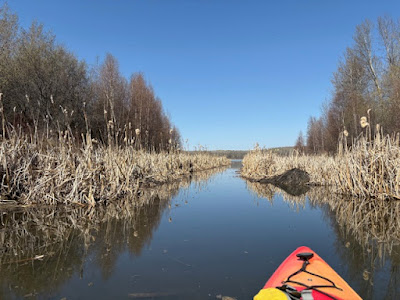
The passage was open and navigable. There was six to eight includes of water all the way through.


The exception was at the very east end (picture below) where the bottom comes up (I suspected a buried log) and there was only 3 inches of water. We bum-scooted over this. I'm not sure what this means for later in the year if there is no rain and the lake level starts to drop.


Lots of birds in the eastern basin and the noise from the frogs was insane.


We had lunch floating in the eastern basin and then paddled back to the launch. 


Overall, this was a lovely morning. Bright sun, 20 degrees, and no bugs!

Saturday, April 26, 2025

Hubbles Lake, North Shore Entry

In mid-October, I went to Hubbles Lake to find the public access through crown land (thanks to Bevin for the tip). The easiest access is on the east end through the Allen Beach Resort, but they charge a day-use fee, are only open in the high season, and sometimes restrict access.


While there is a public access point on the NE shore, there is no parking on the roadway within walking distance. You can get in about half way down the lake (green arrow above, enter 17 Lakeview Avenue, Carvel, AB into your nav). You might snag one of the two parking spots. You may also be able to park on the side of the road, although whether this is permissible under the Parkland County traffic bylaws is hard to fathom.


The lake requires a 400m carry (blue arrow) along some ATV paths. It isn't a long carry but there are some challenges. There is a small valley and ridge right away.


Then at the top, you hand a left at the intersection and look for the long, steep slope down to the lake. The picture below shows the first half of the descent, looking south towards the lake. Then the path turns east.


The picture below shows the second half of the descent looking north (from the bottom). It is steep and rutted, there are rocks and roots, and also slippery leaves. You'll want to wear good shoes.


At the bottom, there is a little dock (green arrow) that had been pulled for the season in the photo below. Entry was so-so.


The lake was nice. Small, mostly pretty clean, and empty on a Wednesday evening in October.


I did two laps in an hour and a bit and there was some lovely colour.


The Allen Beach resort is shown below.


The sun started to drop towards the cloud bank so I called it and headed back.


The climb back up with the boat on my head was tough. I made it in one go but was huffing a bit and my back was a touch sore the next day. Mostly the footing was just tricky and, of course, my arms were busy with the boat. This would likely be less challenging with two people carrying two boats.

Saturday, March 29, 2025

Kalamalka Lake, Kaloya Regional Park

In late September, we had a second paddle on Kalamalka Lake near Vernon, this time out of Kaloya Regional Park. This was an easier entry than the Kalamalka Lake Provincial Park, requiring just a 20m carry over grass and sand from the parking lot.


You can launch off either the western beach (gravel) or the sandier eastern beach. We chose the latter. There are pit toilets and change rooms here as well as picnic tables and a short walking trail around the park.


We paddled north on the eastern shore about 3 km, basically to the second point of land.


The shoreline is rocky beaches and there are plenty of no trespassing signs.


Just past the second point (below) is the Kalamalka Lake cave.


The cave entrance is hard to miss given the graffiti.


It is a shallow cave (you can just barely get your boat inside) and has an opening in the roof.


We went bit further up the shoreline (which gets steeper) before turning back south.


Kalamalka Lake joins Wood Lake through a narrow and shallow channel in the SW corner (you drive over the channel to get to Koloya Park).


We took a quick tour through and into Wood Lake and then decided to turn around. Our arms were tired from the previous day's lengthy carry.


We ended up back at Koloya Park but on the western beach (which has a marked swim area). We then hung out here, reading books and having lunch.


Overall, this was a nice paddle. The terrain wasn't quite as spectacular as the provincial park and there was more boat traffic. But the entry was way easier and the cave was pretty cool. There was also direct access to Wood Lake off a gravel beach nearby. 

Saturday, March 8, 2025

Lower Waterfowl Lake

In late September, we took a trip to BC. Our first stop along the way was Lower Waterfowl Lake, which is located just south of Saskatchewan Crossing on the Icefields Parkway. The best access is through the campground. We arrived to find the campground closed for the season, so we backtracked to the lookout on the Parkway and put in from there.


The Parkway lookout is pretty busy with cars and tourists. It also requires carrying the boats down a short, but steep path and then navigating the rocks at the bottom. This was no big deal but might be a barrier if you have mobility issues. There was a Parks self-certification box here but no other amenities and our self certifications actually got checked as we were putting in.


That done, we managed to get into the boats without dumping in front of the huge crowd of onlookers (!) and we set off counterclockwise.


Lower Waterfowl is beautiful and we had great weather for mid-September (on the return trip, there was sleet!).


It looks like you could also access the lake from the north end (there is a pull out and people had walked in). This might have been an easier access, at least at the shoreline. 


We then followed the shore to the outflow in the northwest corner.


To get a good look, we beached the boats and walked a bit. The bottom of the lake is rock on silt but it is gooey in places!


We then came back south on the western shore, which was lovely.


There is a nice sandy spit if you'd looking for a picnic site or to have a very cold swim.


The inflow (from Upper Waterfowl Lake) is on the south end. There are a couple of braided channels. We tried paddling up but couldn't get very far (current was strong).


We walked the boats up a ways (again, ground was pretty soft) and then had a short run down to the lake. You could portage your boats to Upper Waterfowl Lake. That would be about a kilometre carry. You can also access Upper Waterfowl from the campground (again requiring a carry; this access was also closed). 

It isn't clear if Parks deems these two lakes separate bodies of water when they apply their 48-hour dry rule. We didn't have time to do both lakes, so we just did a short river run and continued around the lower lake.


Below, you can see the campground access point to Lower Waterfowl. The perimeter of the lake is about 4.5km and would take maybe an hour. We fiddled about at the inflow and outflow and spent maybe two hours here. If you did Upper and Lower you'd be looking at about 3 hours.

Overall, a lovely lake and a great paddle. Maybe not as large and beautiful as nearby Bow Lake, but there was no one here, whereas Bow Lake was jammed with cars and boats when we went by.