I tried my luck a second time at Lily Lake, just northwest of Darwell in late May. We'd tried to get in here last year but the trail had been too swampy. The lake also fills with lily pads in the summer, making it hard to paddle, so the trick is to time a visit when the pathways are dried out but the lake is not yet overgrown.
Access is through the JBJ McDonald Conservation Land run by the Edmonton and Area Land Trust and there are two options: the western approach (green arrows) or the eastern (pink arrows).

A couple of notes.
- EALT does not allowed wheeled vehicles (e.g. bikes) on the trails so boat trailers are out and you have to carry your boat. You can do a tandem carry for most of the way on both approaches but both have sections where you'll be single file (I did the whole thing Mr. Canoehead style).
- Both approaches are about 550m long over moderately challenging and sporadically wet terrain. You need good boots. Crocks, even in sport mode, won't cut it.
- There was also a tonne of cougar scat, so you'll want bear spray. You may also see bear, moose, and livestock!
Eastern Approach
Having tried the western approach last year, I decided to try the eastern approach. There is a nice parking area (grass) and then you head south up a gentle slope (behind my truck). The trail is almost dead straight and there is barbed wire along one side to follow (no chance of getting lost).

The first bit is forest with a few roots and downed trees to navigate. Then you drop down to a swamp, which was the trickiest part. The picture below is shot looking north. You want to stay close to the barbed wire fence (left in this shot) and you'll walk on tufts of grass and downed logs to avoid a very wet foot. The fence posts are useful to steady yourself except one of them is super loose (surprise!).


Eventually, you come out at the edge of the lake and then things get super soft and you are on real muskeg. The last 4 meters to the edge is basically a floating matt (so from the bow of the boat below to the water). I weight 235lbs and it held me most of the way to the water.

I changed from boots to water shoes here. If you can zoom in on my watershoe, you can see the water coming up out of the ground as I sink in on the left side of it. The launch was basically pushing the boat towards the water until I started to really sink and then I got in and bum scooted the boat for the last five feet.


This entry point has a large white EALT sign, so is easy to find from the water. Of the two approaches, I'd say the eastern approach was the easiest carry (flat, straight) but the harder entry and exit. Since I was there, I walked the western approach as well.
Western Approach
The western approach starts from a nice parking lot. You lift over the fence and head south down this old homestead road. The footing is good here.

About two-thirds of the way down you'll see a trail head off to the left (southeast) up this hill. You go up the hill and down the other side. The trail is obvious and all of the side spurs have been flagged as closed for restoration.

At the bottom, you cross a soft spot on these steel ramps (easy). There is another soft spot just beyond this with no ramp. This was mostly dry this time but was a sodden morass last year when we tried this approach.

Then things dry out and you walk south on a wide, soft trail.

Eventually, you hit an intersection and you hang a left down a single track that is soft and can be very wet. There is a map here (the image at the top of this post is from that map). The single track splits and you want to stay to the right (you can pretty much see the lake at that point).

This sign is pretty on point!

Once you get out of the trees and can see the lake, you are on muskeg floating over the water. So, if you you pulse your foot up and down, the ground bounces up and down in a rippling way. This is both kind of fun and disconcerting but you can walk right to the edge. The water is pretty deep here (looks shallow but the mud is so soft as to be bottomless). I would put my boat on the grass and then bum scoot in. YMMV.

This entry/exit was not signed and would be easy to miss from the water (shot below).

I would say this approach is the harder carry (more up and down and the single track is windy) but the entry is easier.
The lake itself is lovely and has a perimeter of about 3km. You can see, even in late May, the lily pads that give it its name.

There were lots of birds. These two swans followed me around the lake. There were also ducks, beaver, muskrat, and lots of shorebirds.
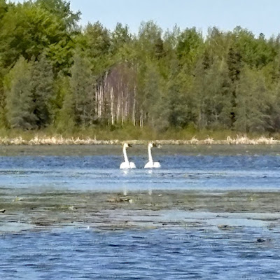
I did see an osprey circling but it didn't dive. The cormorants flew over and there were no loons. Maybe the lake is too shallow to have a decent fish population?

It took me about an hour to go around but I was taking my time and poking about. The lily pads were just numerous enough to be slightly annoying (grabbing at my paddle). The lake gets fully covered in the summer and I would think would be unpaddleable like that.


Overall, I had a lovely paddle. I was the only one on the lake, there are no motorized boats, the water was clear, and there are no cabins.


This probably isn't a paddle for everyone because of the carrying required and the slightly more challenging entry. I'm not sure I'd go back every year (Wabamun, Lac Ste. Anne, and Lake Isle are all within a few kms). But it was an interesting lake to try.


