Sunday, August 28, 2016

Hermitage Pond, Edmonton

Hermitage Pond is located in Hermitage Park, in NE Edmonton. Access is pretty straight forward: east on the Yellowhead until you hit Victoria Trail (right before the river). North on Victoria Trail and hang a right at the Tim Horton's and follow the road down through the community into the park.


There are multiple ponds but only one with easy access and suitable for a paddle. The carry for the parking to the dock is 50 feet or so down a gentle slope. We just put in from shore to the right of the dock in the picture above.


The pond has two big islands and one tiny one. The islands divide the pond into two parts (main body and then an eastern channel. We had a nice time poking around and two circuits of the pond took us maybe 40 minutes (with lots of bird watching).


There were lots of geese there flocking up to head south. Geese apparently also nest on the island based on the discarded eggs.


It was quite over cast and brisk when we went (early on a Sunday). I've seen the pond hopping on nicer days and even a paddle board soccer game in progress. The pond is kind of gross and weedy so I woudln't want to fall in!


The wild life was pretty amazing: geese, ducks, loons, a heron and two muskrat. I tried to get a picture of the muskrat (below) sitting beneath some branches have a snack on something it pulled up from the bottom (snail?).


The pond is very close to the main CN line and there is a train about every 20 minutes! You can see the tanker cars on the trestle bridge in the picture below.


Overall, this is a fun (but short) paddle on a sunny day. A good place for kids to get some experience in a canoe or kayak before heading out to a real lake. It was also nice to have a place to paddle in town when the river is too high to go on safely.

Tuesday, August 16, 2016

Wedge Pond, Kananaskis

Wedge Pond is a small lake (maybe three acres?) located about an hour west of Calgary in Kananaskis Country. The pond appears to be a kettle lake and is significantly lower than the surrounding land.


Access is off Highway 40 into the parking lot. There are toilets here and one sign I saw indicated there was a water pump (although I didn't see that). The lake is about a 200-foot carry downhill from the parking lot (trail heads are obvious).


The pond is beautiful, with clear water. The pond is also stocked, with lots of anglers taking advantage of it.


It was quiet the day we were there but I have often seen it hopping with families swimming, rafting, kayaking, etc. The beach is rocky. The western-most part of the lake shore can be a bit boggy and was full of tiny forest frogs the day we were there.


There isn't much adventure here for experienced paddlers but it is a safe and fun place for kids to learn how to paddle on their own.


There is also a hiking trail (maybe one kilometer) around the lake. This might make a good paddle for kids combined with the Mount Lorette Ponds, just down the road.

Sunday, August 14, 2016

Mount Lorette Ponds, Kananaskis

The Mount Lorette Ponds are a series of ox bow lakes cut off from the Kananaskis River by Highway 40. There are four (I think) ponds and the two largest have a paved walking path around them (maybe a 20 minute stroll to do the full circuit). There are washrooms in the parking lot and many picnic tables.


The ponds are stocked and are a popular fishing spot. This is especially true of the large pond (second from the left in the map below) and its shores are often full of anglers. You can get a kayak in here from the shore and it is about a 200-foot carry from the parking lot.


The pond second from the right (with the arrow-shaped dock) seems to rarely have anglers and is a lovely paddle with lots of interesting features. Access is from the shore (or perhaps the dock, although it is a bit high for that).


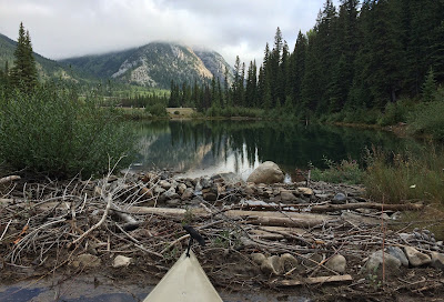
There are beavers in the area so there are both beaver dams and beaver-reinforced man-made dams. The lake itself is lovely and mostly shallow (good for kayaks; not so much for canoes).


This is a lovely place to turn kids loose because there are really no hazards: there are deep spots but there is no real current or worry about wind. There is lots to see on the bottom and on the shores.


There fish in the lake (mostly the west end by the bridge) and the lake is crystal clear. I spent a fair bit of time recovering lost fishing tackle from branches and trees (five floats, several lures). We saw a bald eagle while we were paddling.


While the Mount Lorette Ponds are hardly a challenging paddle, this was maybe the most fun I had during out trip. It is peaceful, interesting and we could let our 13-year-old paddle solo without any real worries. This might be a good paddle to combine with the Wedge Pond.

Lower Kananaskis Lake, Kananaskis

Lower Kananaskis Lake is a reservoir located in the Peter Lougheed Provincial Park, just east and north of Upper Kananaskis Lake.


There are multiple access points. We used the day use area at the south end of the lake just north of Lower Lake campground. The parking lot has toilets. The lake level looked lower this year and it was a long haul to the edge of the lake (500 feet).


The edge of the lake was pretty boggy although there was a rockier shore slightly south where a creek joins the lake. There were kayakers and paddle boarders on the lake when we were there.


The lake is long (8km?) and narrow (maybe 1km?) and can sometimes be quite windy. Upper Kananaskis Lake looks to be much nicer to paddle, but that may just reflect where we chose to access the lake. There is a boat launch at the northern end of the lake by the Canyon Creek campground. The Interlakes Campground (on the west shore) also appears to have lake-side camp sites.


We actually had a better time wandering up the creek bed!


The interpretative centre for Peter Lougheed Park is worth a visit. It has washrooms, trail maps, some educational displays and a lovely lodge setting. There is also a bike path connecting the various camp grounds along the lakes, but this was closed due to bear activity while we were there.

Friday, August 12, 2016

Upper Kananaskis Lake, Kananaskis

Upper Kananaskis Lake is a man-made reservoir located off Highway 40 in the Peter Lougheed Provincial Park. It is one of two paddlable lakes in the park (the other being the Lower Kananaskis Lake). The upper lake is the nicer lake of the two. Apologies for the panoramic distortion in the picture below.


The parking area has a boat launch, toilets and picnic sites. If you don't use the launch, the carry to the water is maybe 40 feet and launching off the beach is just fine. This area is located in the small bay in the bottom right of the map below.


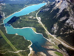
This aerial shot (which includes part of Lower Kananaskis Lake on the right) also gives you a sense of scale (the bay we paddled in is at the bottom of the picture). The lake itself is big and, thus, is prone to some serious waves plus rapid weather changes!


The bay offers some interesting sights, including a rocky island (visible in the shot below on the left) and a waterfall (in behind the island on the far shore). There are other islands further down the lake.


The picture below is a shot back towards the beach area from the other side of the island. The scenery is truly amazing (when the weather is good). Bad weather makes the lake much less pleasant (as it is bracingly cold).


The kayak in the picture below gives you a sense of the scale of the lake and is a good lesson in foreshortening.


This was one of the nicest paddles we've had in the mountains: +25C, no wind and lots of sun.  The interpretative centre at the entrance to the park is also a nice stop, with washrooms and some educational-type displays in a mountain lodge setting.

Wednesday, August 10, 2016

Barrier Lake, Kananaskis

Barrier Lake is a reservoir located in Kananaskis country, about 90 minutes west of Calgary.  Head west towards Banff on Highway 1 and then turn south on Highway 40 (at the casino...). The lake is about 20km past the turnoff.


There are two access points for the lake. The first is at the very north-east corner of the lake near the dam. There is a small parking lot and a steep carry down to the water. Barrier can be windy and the wind generally blows towards this end of the lake. This means I've seen some pretty serious rollers (three feet and more) down here.


The better access is just down the road at the Barrier day use areas. The signage is the pits but basically turn in and stay to the right and you eventually wind your way down to the boat launch and beach. There are pit toilets here and lots of picnic sites.


The water level in the reservoir was dropped this year (for three years, I think) as a flood control measure. Thus the boat launch (above) ends about 50 feet shy of the edge of the water. The beach is sandy and it is a short carry to the (very brisk) water.


This year, Kananaskis Outfitters was running a boat rental operation here with canoes, kayaks and paddle boards. The rental site was staffed Friday to Sunday but arrangements could be made to access boats during the week at the outfitters office in Kananaskis Village.


We rented a pair of kayaks so all three of us could paddle. We also took a great paddle boarding lesson arranged through the outfitters. The beach got very busy as the day went on with more than a dozen boats and several groups. The wind picked up as the day went on and the lake is prone to both strong wind gusts and rapid changes in the weather.


Paddling west and then south (towards the point where the river enters the lake) was more interesting than paddling towards the north and east (which takes you towards the dam). Our paddle boarding instructor said that the delta exposed by the lower water levels is covered in old golf balls that have washed down stream over the years but we didn't get that far.

Tuesday, August 9, 2016

Spray Lakes Reservoir, Canmore

The Spray Lakes Reservoir is located just south and west of Canmore as you climb up towards the Nordic Centre. It is located on the same road and very close to Quarry Pond. The first access point is just past the dam itself on the south side of the road.


There is a small beach and the carry is less than 50 feet. The lake extends back into the mountains for quite a distance. For much of that, the reservoir is narrow.


There is quite a lot of wild life to be seen here. And the picture below was shot from the parking lot of the Canmore Nordic Centre (which has a cafeteria, washrooms, and an equipment rental centre).


This might be a good paddle to combine with a morning or afternoon at Quarry Lake.

Quarry Lake, Canmore

Quarry Lake is a man-made lake on site of an old mine. It is a small lake, maybe one-and-half acres in area. The area is very pretty.


The lake is located a few minutes south and west of Canmore, as you climb up the hill towards the Nordic Centre. The lake is about a 400-foot carry from the parking lot and there are toilets, picnic tables and a small beach.


The lake is usually quite busy with swimmers, fishing and various watercraft. There is likely a whole day of fun and it would be a good place to let kids paddle on their own or to learn to paddle board. There is a walking trail around the lake and (pictured behind Jessica in the shot below) there is a small cliff to jump off of.


The water is cool (spring fed) so swimming is really only an option in high summer. There are plenty of cycling and walking trails, however.


This might be a good paddle to combine with the Spray Lakes Reservoir just down the road.